
Mountain biking and pleasure biking
Bike fans of all ages - from the pleasure cyclist to the sports fanatic - will find the bike routes to their liking in Gastein. Pleasure tours with great rest stops or varied mountain bike tours entice you to visit the clear mountain lakes.
New tours and trails fulfill the heart's desires of cyclists and bikers. The new signage makes finding your way even easier, even on fast passages. Don't miss out on any Uphill Challenge or simply enjoy the idyllic cycling routes - just as you like. We at Thermenhotels Gasten will be happy to advise you on choosing the right routes. Comprehensive information material and maps are available at the reception.
Selective or cozy
If you want to really get into an uphill challenge, the gigantic view of the Hohe Tauern beckons as a well-deserved reward on the route to the summit of the Stubnerkogel at 2,254 meters or to the Graukogelalm at an altitude of 1,400 meters. Then, on the subsequent downhill, you will experience pure joy as you ride through the alpine landscape. If your ambition to climb heights by bike is limited and you still don't want to miss the rapid descent, simply take your bike in the gondola to the Fulseck and jet back down to the valley on forest paths. The spectrum of tours ranges from the Gasteinertal round tour to discover the entire valley, suitable for the whole family, to the very challenging cross-valley single trail over the Fulseck into the Grossarl Valley. The sporty medium-difficulty tour to the Gadaunerer Hochalmen leads to the beautiful alpine plateau above Bad Hofgastein. The reward for the 1000 meters of altitude overcome is a Schmankerljause in front of one of the mountain huts, the majestic silence of the impressive mountain scenery is broken only by bees buzzing and cow bells ringing. After the effort still chilling in the spa - this is vacation for all the senses.
The Gastein Valley is also a section of the popular Alpe Adria Cycle Route from Salzburg to Grado. According to the motto: "The journey is the destination", you can spend a few enjoyable days in the Gastein Valley before continuing your journey.
on the way with the guide
Let a certified mountain bike trainer accompany you on your half-day beginner's tour or a full-day power tour. During the guided MTB tour you will discover secret places in the Salzburg mountains and work on your riding technique at the same time. On very different routes, you will learn how to ride uphill in a way that is easy on your energy, as well as how to ride safely on the various surfaces or selective hairpin bends. The valuable tips and tricks will enrich your sporty vacation in Gastein. With a bike and hike tour you also secure a summit experience. But also with gentle bike tours or trying out an e-bike, the Gastein bike guides will support you and take you to the hidden places in our beautiful valley.
Overview of all mountain bike tours
BIKE TOURS STARTING IN BAD HOFGASTEIN
RASTÖTZEN:
Main starting point: Bad Hofgastein village center
Difficulty: medium
length: 17,15 km
Time: 2,5 h
The Rastötzenalm is a challenging route for mountain bikers, the serpentines are quite steep and really relaxing sections are rather rare. Already in the village area it goes steeply up the Wasserfallgasse to the bridge. Here the Kirchbach is crossed and already comes above the cemetery the next steep section up to Café Sonnberg. Here
we turn left in the direction of Annenkaffee. Via a forest road leading through dense coniferous forest, we wind our way up in serpentines to three farmed alpine pastures. These are nestled in a basin between several peaks. One of them is the Gamskarkogel, the highest grassy mountain in Europe at 2467 meters. The alpine pastures invite you to linger and tempt you with homemade products for refreshment.
BIBERALM-WIEDNERALM:
Main starting point: Bad Hofgastein village center
Difficulty: medium
Length: 26,16 km
Time: 2,5 h
On the way to the Biberalm and Wiedneralm above the Hofgastein district of Breitenberg, there are always beautiful views in the direction of the southern Gastein Valley. The tour begins in the center of Bad Hofgastein and leads north along a section of the Gastein cycle path to the Bad Hofgastein train station. In front of the station, the road branches off to the left, you pass an underpass and begin the climb through the Breitenberg district. Again and again, the view sweeps southward and reveals magnificent views of the Gastein Valley. At Brandebengut at 1151 m, the route continues on a forest road. The path now leads through wooded areas, gravel and asphalt sections alternate. Shortly before you reach the forest line you come to the fork in the road Biberalm - Wiedneralm. Depending on which alpine pasture you choose, it is only a short distance to your destination. Both alpine pastures spoil you with all kinds of homemade food, from their own organic beer to freshly made doughnuts.
GADAUNERER HOCHALMEN:
Main starting point: Bad Hofgastein village center.
Difficulty: medium
Length: 29,53 km
Time: 2,5 h
Starting point is the center of Bad Hofgastein. Follow the signs up to the Angertal valley. From there the gravel road starts passing the ski center Angertal. Pass the barrier at the Waldgasthof and ride relatively flat into the back of the Angertal until you have crossed the Angertalbach. After the bridge, take the path to the right uphill. Above the tree line you reach the Gadaunerer Hochalmen, which look like a small alpine village due to the numerous alpine pastures. The alpine huts invite you to rest and enjoy the wonderful view of the mountains.
ANGERTAL CIRCUIT:
Main starting point: Bad Hofgastein town center
Difficulty: medium
Length: 10,92 km
Time: 1,5 h
The bike tour starts in the center of Bad Hofgastein and leads in a southwesterly direction to the district of Lafen. From here the ascent begins and leads via the railroad station Angertal to the Hartlgut. From here the gravel road into the Angertal begins. Here a rest at the idyllically situated forest inn is recommended. The way back leads past the ski center Angertal again and via the Angertalstraße back to Bad Hofgastein.
STUBNERKOGEL ALMENRUNDE:
Main starting point: Bad Hofgastein town center
Difficulty: medium
Length: 29,53 km
Time: 2,5 h
Starting in Bad Gastein you walk along the Erzherzog Johann Promenade into the Angertal valley. Here you turn left and take the forest path to the summit. Numerous attractions of the Gastein mountain railroads are waiting to be discovered here. The route continues down into the valley via the mid-station of the Stubnerkogel lift to the Stubneralm, which tempts hungry cyclists with homemade snacks. The tour then leads downhill, past the Jungeralm and uphill again a bit to the Schattbachalm. With a view of the wide alpine basin of the Gadaunerer Hochalmen, you can also enjoy home-grown products here. The long descent leads back to the Angertal valley and further on
to the starting point in Bad Gastein.
STUBNERKOGEL SUMMIT:
Main starting point: Bad Hofgastein village center.
Difficulty: difficult
Length: 36,59 km
Time: 3 h
Starting point is the center of Bad Hofgastein. Follow the signs up to the Angertal valley. At the ski center Angertal the ascent begins along the ski slopes over the gravel road past the Stubnerkogel middle station to the summit of the Stubnerkogel.
SCHATTBACHALM:
Main starting point: Bad Hofgastein village center
Difficulty: difficult
Length: 28,2 km
Time: 3 h
From the town center follow the signs to the Angertal. There, on the east side of the Stubnerkogel, the gravelled goods road begins in the direction of the Stubnerkogel mountain station. Then you come to the turnoff in the direction of Jungeralm/Schattbachalm. First you cross the lift lines of the Angertalbahn and then the Senderwahl. The path to the Schattbachalm is slightly uphill.
BERTAHOF TRAIL:
Main starting point: Schmalzgrubengut/Hauseben.
Difficulty: medium
Length: 1,4 km
Time:0,5 h
The first Gastein single trail is easily accessible from Bad Gastein and from Bad Hofgastein via the Gasteinertal Round and the Erzherzog Johann Round. On the trail you can get your first impressions of riding on single trails. At the beginning it starts medium steep. After the railroad underpass, the forest floor provides the necessary flow. Towards the end, it gets a bit more technical before the pulse slowly drops again when you leave the trail. The trail ends near the Gastein swimming lake. After a hot day on the bike maybe just the thing! From there you can cycle back to Bad Hofgastein or Bad Gastein along the Gasteinertal cycle path.
BIKE TOURS STARTING IN BAD GASTEIN
ASTENALMEN:
Main starting point: Bad Gastein spa and tourism association
Difficulty: easy
length: 13,81 km
Time: 1,5 h
From the Kur- und Tourismusverband in Bad Gastein along the magnificent Kaiser-Elisabeth-Promenade, the trail leads in the direction of Böckstein, with a view of the pilgrimage church, to the Evian spring. Continue along the old Nassfelder path to the Asten alpine pastures. A petting zoo, a children's playground and delicacies from the region attract young and old for an excursion.
BELLEVUE ALM:
Main starting point: Bad Gastein spa and tourism association
Difficulty: easy
Length: 3,9 km
Time: 0,4 h
Starting at the Kur- und Tourismusverband in Bad Gastein, you first walk a short distance along the Gastein main road. Then the turnoff to the right is signposted. After passing the narrow railroad underpass, turn right again. From here, follow the forest road, which begins steeply, but then flattens out after the first bend. In the legendary Bellevue Alm, fondue is served in addition to Austrian delicacies.
PROSSAU:
Main starting point: Bad Gastein Raiffeisenbank
Difficulty: easy
Length: 18,14 km
Time: 1,5 h
The Prossau is located at the end of the Kötschachtal in Bad Gastein. You start the tour at the Raiffeisenbank Bad Gastein. Here you follow the signs past the Bad Gastein waterfall into the Kötschach valley. Passing the Malerwinkel, you cycle along the Kötschach into the valley. You first reach the Himmelwandhütte, which invites you to take a break. The homemade strudels are especially recommended here. Afterwards you pass the Himmelwand, where the path slowly begins to rise and you reach the Alpenhaus Prossau.
MIDDLE STATION GRAUKOGEL:
Main starting point: Bad Gastein Raiffeisenbank
Difficulty: medium
Length: 7,44 km
Time: 1 h
From the Raiffaisenbank Bad Gastein you start in the direction of Windischgrätz and Schachengut. Just after Schachengut the gravel road begins and winds in serpentines through the forest to the middle station of the Graukogel lifts. From Bad Gastein's local mountain
the view far beyond the valley and the Alm Grau Mitte invites you to linger. A morning bike tour with subsequent refreshment at an all-round alpine breakfast is highly recommended.
ERZHERZOG-JOHANN-RUNDE:
Main starting point: Bad Gastein Kur- und Tourismusverband (spa and tourism association)
Difficulty: medium
Length: 12,32 km
Time: 2 h
From the Bad Gastein Kur- und Tourismusverband you enter the promenade in a northerly direction. The beginning of the path is adorned by a bust of Archduke Johann, a reminder of the faithful guest of Bad Gastein. Surrounded by leafy and coniferous trees, you continue along the promenade until you reach the railroad crossing. Here begins the ascent to the Hinterschneeberggut. Further on you take the asphalt road downhill and after a while you pass the turnoff to the Bertahoftrail. You follow the road and after the village Hinterschneeberg you turn uphill towards Hartlgut. Here the gravel road begins in the direction of the Angertal Ski Center, where a little further into the valley the Waldgasthof Angertal
is a good place for a break. The way back leads along the Angertalstraße to Bad Hofgastein. Here you follow the signs for the Gasteinertal cycle path and head south back to Bad Gastein.
PATSCHGSTUHL:
Main starting point: Bad Gastein Raiffeisenbank
Difficulty: difficult
Length: 19,61 km
Time: 3 h
A classic among the mountain bike routes in Gastein is the ascent to the Patschgstuhl. The route on the forest road below the Hoher Stuhl and the Feuersang offers about 1000 meters of uphill and a beautiful view of the Gastein Valley. Towards the south, views of the Höhkar and the mountains above the Anlauftal valley open up. In Bad Gastein, past the train station heading south, turn right just before the railroad bridge up Palfnerstrasse, where signs point to the Windischgrätz. After a short approach, turn left before the bridge (Böcksteiner Waldweg). On the gravel road you take the first serpentines through the forest. The path is basically passable without obstacles and the gradient is relatively constant. After a longer straight stretch without an ascent, you pass a game feeding station in a sharp bend. After that, it goes without any striking spots until you reach the forest line. From here it is only a short distance
stretch to the Patschgenalm or the Eisenbahnerhütte.
BIKE TOURS STARTING IN DORFGASTEIN
GASTEINER-ROUND
Main starting point: Dorfgastein community park
Difficulty: easy
length: 44,93 km
Time: 3 h
The Gastein Cycle Path is a circular route that leads to the most beautiful places and sights of Gastein. It starts at the beginning of the valley in Klammstein. From there it goes south. Via the villages of Dorfgastein and Bad Hofgastein, the path leads along the Gasteiner Ache river
to Bad Bruck. From there there is an ascent to master until you arrive in Bad Gastein. The Gastein bike path is a feeder to all mountain bike routes in the Gastein Valley. However, you can start from anywhere.
STROHLEHEN-DORFERBERG CIRCUIT:
Main starting point: Dorfgastein community park
Difficulty: easy
Length: 8,11 km
Time: 1,5 h
The starting point of the tour is the Gemeindepark in Dorfgastein. From there the asphalt road leads in the direction of Unterberg. Before you get directly to this part of the village, the goods road branches off to the left in the direction of Strohlehenalm. The forest road now winds uphill through the forest and provides pleasant shade on hot summer days. The unique view of the village is particularly impressive. At the turnoff to the Strohlehenalm (not managed), take the Fostweg to the left in the direction of Dorfgastein. Via the Dorferberg you get back to the starting point.
KÖGLERALM:
Main starting point: Dorfgastein community park
Difficulty: medium
Length: 19,57 km
Time: 2 h
Starting from the Dorfgastein community park, you cycle in the direction of Unterberg. There you follow the signs uphill - and cycle about 500 meters of altitude along the forest road uphill. On the way you pass the turnoff to the Amoseralm - another beautiful alp in Dorfgastein. At the highest point of the tour you should definitely take a break at the "Drei Waller Kapelle" and enjoy the special atmosphere at this place of power. From here, a goods road leads further to the Kögerlalm. The alp is open daily during the summer months and offers culinary delicacies from its own production.
AMOSER HOCHALM:
Main starting point: Dorfgastein community park
Difficulty: medium
Length: 19,91 km
Time: 2,5 h
The tour to the Amoser Hochalm leads into a very beautiful alpine pasture area above Unterberg, a northern district of Dorfgastein. The tour starts in the municipal park of Dorfgastein. Follow the signs to Unterberg. At the Amosergut the ascent begins, shortly after the asphalt ends. Soon there are beautiful views over the Gastein Valley. At the Amoseralm (managed) at about 1200 m you will find a rest area. Experienced bikers continue on the forest road, which gradually increases in difficulty. Once you reach your destination, you will be rewarded for the effort of the ascent. The Amoser Hochalm (not managed) is located at the foot of the Bernkogel, which with its steep rocky flanks is considered a particularly striking point in the landscape.
PRÄAUALM LOOP:
Main starting point: Dorfgastein community park
Difficulty: difficult
Length: 20,54 km
Time: 2,5 h
From Dorfgastein you first drive in the direction of Unterberg and then turn left at the wood storage area, approx. 500m before Unterberg uphill in the direction of Strohlehenalm or Präaualm. A corresponding signpost still on the road to Unterberg is hard to miss and shows the right way. After a few serpentines you reach the junction Präaualm/Strohlehenalm at 1,080 m above sea level. If you now want to reach the Präaualm, continue straight ahead through the Dorfer forest. With a moderate but steady incline, this road now winds around the Tagkogel and far above the district of Luggau into the Luggauer Graben. Here the route is very exposed to the sun and is by no means recommended during lunchtime. Arrived at the Jägerhäusl at exactly 1,600 m above sea level, the road splits and you have to take the steeper, somewhat worse path up to the right. From there it is only about 15 min. to the destination, although it is allowed to descend once when the gate is closed. The Präaualm is the highest alpine pasture in Dorfgastein at 1,808 m above sea level. With joy and enthusiasm
to nature and to the animals the hosts manage the high alp throughout the summer. The production of organic dairy products, such as alpine cheese and butter, as well as the processing of natural herbs and fruits to juices, jams, ointments and much more is a matter of the heart of Monika and Sepp Rieser.
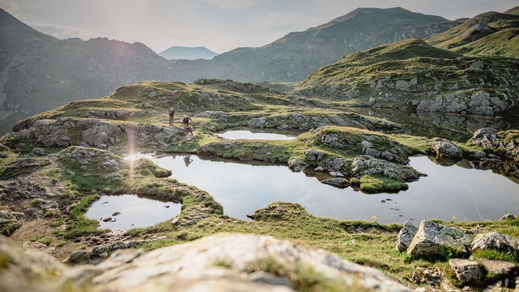
FULSECK TALÜBERGANG DORFGASTEIN/GROSSARLTAL (single trail):
Main starting point: Dorfgastein community park
Difficulty: very difficult
Length: 33,11 km
Time: 4 h
Starting from the Dorfgastein community park, the trail leads past the tourist information office in the direction of Alpengasthof Hauserbauer. Passing the Mühlwinkelhütte, the trail leads along the Gruberwaldweg in the direction of the middle station and on to the top station. Once at the top, you will be rewarded with magnificent views. To the south, the Gastein Valley opens up with its mountain peaks and to the north you can see the Hochkönig as well as the Steinerne Meer. The local mountain of Dorfgastein offers various leisure activities under the motto "Adventure - Water and Wind". A refreshing oasis of peace and relaxation at the Fulseck is the Spiegelsee. Through the bike connection Dorfgastein-Großarltal mountain bikers have for the first time the opportunity to also use the single trail Großarltal. You ride from Dorfgastein by bike or with the
the Gipfelbahn-Fulseck uphill and then via the signposted mountain bike route to the start of the single trail at the Panoramabahn mountain station in the Grossarl Valley. From there this leads on 2 variants 10 km and 960 hm into the valley. The single trail has the difficulty level S1.
Back up the mountain you can only get with the Panoramabahn Grossarltal (fee required). Arrived at the mountain station, the signposted mountain bike route leads back to Dorfgastein.